Descendants of Jacob Keckley, Sr. - Hometowns
Where did Elias and Catherine Kackley live & die?
At Pembroke Springs and Mount Williams, Frederick County, VA.
At Pembroke Springs and Mount Williams, Frederick County, VA.
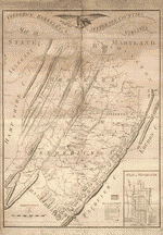
Varle, Charles, and Benjamin Jones. Map of Frederick, Berkeley, & Jefferson counties in the state of Virginia. [Philadelphia: s.n, 1809] Map. Retrieved from the Library of Congress, www.loc.gov/item/2008621756/. Original map is in University of West Virginia Library.
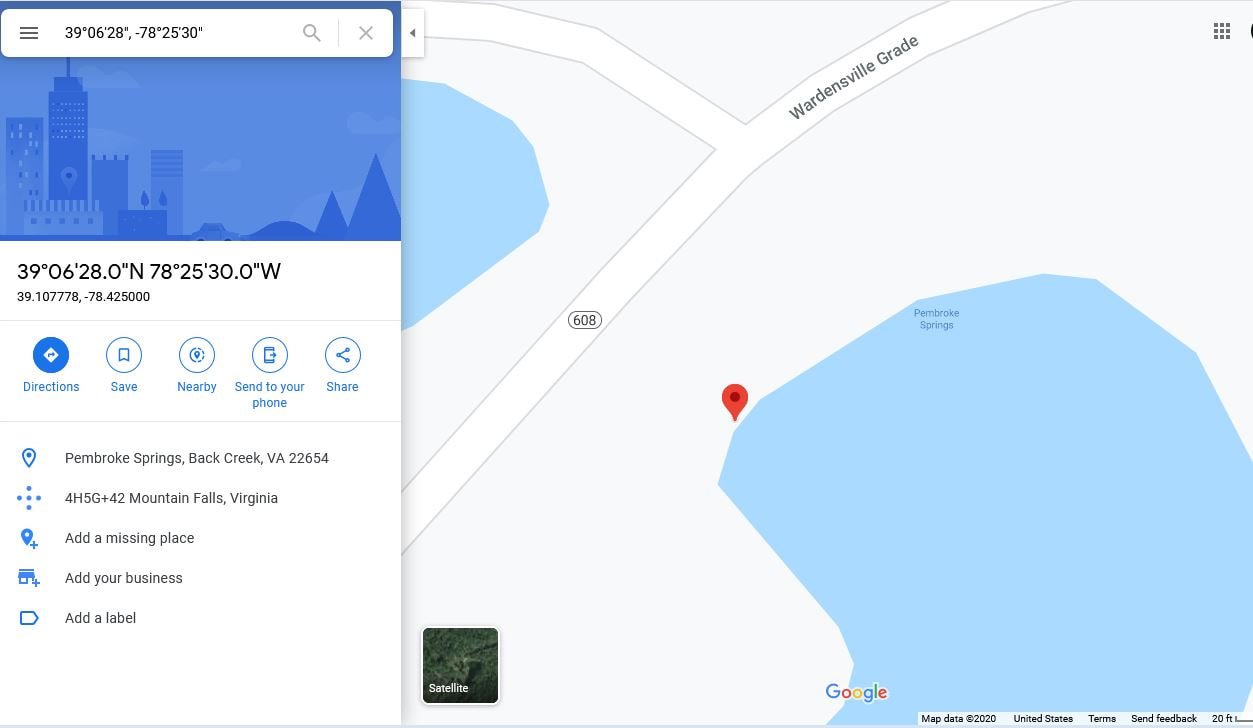
Google Maps showing location of Pembroke Springs in Frederick County, VA, 6.3 miles southwest of Mt. Williams along VA-608, Wardensville Grade.
|
Elias Kackley was the fifth of seven children born to Alice and Jacob, Sr. He was born circa 1748 and died in 1819 in or near Mt. Williams, VA - the last of my direct line to live and die in Frederick County, VA. His profession was farmer and saw miller (1). Like thousands of other Americans, many of his sons, daughters, nephews and nieces migrated to other parts of VA or the US including Ohio, Illinois, Indiana and other westward destinations.
Elias and Catherine married sometime around 1768 and had 11 children, 10 who lived to adulthood and marriage. They are reported to have owned land at "Pembroke Springs" in various genealogies, including the 1983 article by W.L Kern. In fact, Dr. Kern phrases it this way - "His land included the Pembroke Springs in Frederick County." The 1809 map by Varle and Jones (top left - click on it for high res. version) lists a location named "Penbrook" near the Duck Run in the lower left quadrant. Within the Penbrook area, icons indicate 4 mills, 3 plantation or farms and a small town. On Duck Run, a mill and a plantation/farm are noted where another unnamed waterway connects with Duck Run - the words "fulling & oil" are on the map at this location. This is most likely the location of Henry Richards' fulling & oil mill (2). Could Elias Kackley's farm and saw mill be at the saw mill icon noted near the "D" of Duck Run? Unknown - but Penbrook/Pembroke appears to have been a small settlement in the early 1800's supporting several millls, farms and homes. On April 11, 1769, Elias bought 225 acres of land from James McLaughlin, somewhere near Bear Ridge in Frederick County. (3) As he and Catherine were newly married at that point and he was only 21, one wonders where the money came from. Did she bring money to the marriage? Did Jacob loan it to them? A survey done in 1781 recorded a total of 286 acres, in two sections of 149 and 137 acres, along Duck Run owned by Elias by 1790. Elias would have inherited "30 pounds of silver or gold" circa 1782, after his father's death (3). In Elias' will dated Dec. 31, 1818, he left most of his land to his 6th child and 5th son, Jonathan Russell. The land bequest mentions lots near the Medical Springs: "all the plantation and survey of land whereon I now live contain one hundred forty nine acres excepting the lotts that I have sold and made deeds for which said lotts are lying and situate near to and joining the Medical Springs. Also I will and bequeath to him one other tract or survey of land adjoining before mentioned containing one hundred and thirty seven acres to him and his heirs forever." Pembroke Springs is listed as having a US Post Office from 1829 to 1866, located 18 miles west of Winchester (4). That puts just about where the current Pembroke Springs Retreat B&B is today (see Google map, left) just off Rt. 608 about 6 miles south of Mt. Williams, VA. Mentions of Pembroke Springs circa 1846-1850 discuss the charter granted to build a turnpike that went by the spot, a 1/4 acre lot passed down in Henry Richard's will and about a hotel built there by Dr. William H. Keffer (5). The hotel and springs were apparently not very successful. One report from 1850 notes that "(t)he waters are considered too cold to bathe in." (6) In a U.S. Geological Survey report from 1981, “Pembroke Springs” is geolocated at 39 deg 06’ 28” N,-78 deg 25’ 30” W (39.107778,-78.425000).(7) At near maximum zoom, Google Maps shows the name on a pond on the east side of Wardensville Grade (VA-608) just southwest of the intersection of Laurel Run and Duck Run. This pond is very near the road leading to the current Pembroke Springs Retreat B&B. The exact location of Elias and Catherine's plantation remains unclear, but the historical records are pointing us to the general area of Pembroke Springs and Duck Run, so let's put a pin in it. When he died in 1818, Elias left all of his land to his sixth child (5th son), Jonathan R. Kackley. Within a few years, Jonathan had sold the land to Travis Glasscock and migrated west to Ohio, where he died of typhoid, circa 1828. So, we move on from Frederick County to Hampshire County, VA with first son, Abraham. Next - Where did Abraham and Christina live & die? 1. Kerns, Wilmer L.. Frederick County, Virginia: Settlement and Some First Families of Back Creek Valley, 1730-1830. United States, Gateway Press, 1995. p 219. 2. Richard, Cassandra Faye, "The Fulling Mill at Mountain Falls, Virginia: An Ethnographic History", 1987. Dissertations, Theses, and Masters Projects. Paper 1539625380. 3. Jacob's House (Cackley/Kackley/Keckley Families), (A History of the Descendants of Jacob Keckley, Sr. (1701-1788) of Frederick County, Virginia), written and compiled by Elizabeth Faith Kackley Qualls, 1990, Gateway Press, Inc., Baltimore. 4. Kalbian, Maral S., Rural Landmarks Survey Report, Frederick County, Virginia, Phases I-III, 1988-1992. p. 181.; Brockenbrough, William Henry. A New and Comprehensive Gazetteer of Virginia, and the District of Columbia. United States, J. Martin, 1835. 5. Cartmell, Thomas Kemp. Shenandoah Valley Pioneers and Their Descendants: A History of Frederick County, Virginia (illustrated) from Its Formation in 1738 to 1908. Berkeley County, WV, Eddy Press Corp. 1909 p. 57, 495. 6. Kercheval, Samuel. A History of the Valley of Virginia, 2nd Ed.. United States, S.H. Davis, 1850. p. 285. 7. Virginia Geographic Names. Alphabetic Finding List, Book 2. United States, U.S. Geological Survey, National Mapping Division, Office of Geographic Research, 1981. p. 424. |